Written and Cartographic Accounts of Amizmiz in History
Amizmiz has been a part of recorded history for several centuries.
Travel accounts of European visitors to Morocco during the past 500
years nearly always include passages detailing their time passing
through Amizmiz. In the nineteenth century, this was especially true
of British explorers stopping at Amizmiz en route to the Atlas
Mountains. Before modern roads, the town was an important stop for
those hoping to cross the mountain range.
Like other Moroccan cities and towns, however, Amizmiz has been known
by a few different names over time.
Variations in the spelling of Amizmiz include all of the following:
Imizmizi, Imizimiz, Imizmiza, Imizmiz, Imisimis, Imismis, Amsmis, Amsmiz,
Amismiz, Amezmiz. There is no
doubt, however, that in each case the writer or mapmaker was referring
to modern-day Amizmiz.
Leo Africanus
Leo Africanus
(1494 - 1554) wrote the first detailed descriptions of Morocco ever published in Europe.
His work, entitled Description of Africa, was published in
1550 in Venice, with an English translation appearing in 1600. His
work includes passages on many cities in Morocco, only some of which
are still in existence today. Among them is his description of a town
called “Imizmizi,” what is now modern Amizmiz.
 “Upon a certain part of
the Atlas stands a city called Imizmizi...and this
city the ancients are reported to have built. Near unto this city lies
the common highway to Guzula over the mountains of Atlas....snow falls
often thereupon...Not far from this town likewise there is a very fair
and large plain, which extends for the space of thirty miles, even to
the territory of Maroco (Marrakech). This most fertile plain yields
such excellent grain, as (to my remembrance) I never saw the like, and
the flour is perfect. Because the Arabians and soldiers of Maroco do
so much molest this plain country, the greater part thereof is
destitute of inhabitants. Indeed, I have heard of many citizens that
have forsaken the city itself, thinking it better to depart, than to
be daily oppressed with so many inconveniences. They have very little
money, but the scarcity thereof is recompensed by their abundance of
good ground, and their plenty of grain.”
“Upon a certain part of
the Atlas stands a city called Imizmizi...and this
city the ancients are reported to have built. Near unto this city lies
the common highway to Guzula over the mountains of Atlas....snow falls
often thereupon...Not far from this town likewise there is a very fair
and large plain, which extends for the space of thirty miles, even to
the territory of Maroco (Marrakech). This most fertile plain yields
such excellent grain, as (to my remembrance) I never saw the like, and
the flour is perfect. Because the Arabians and soldiers of Maroco do
so much molest this plain country, the greater part thereof is
destitute of inhabitants. Indeed, I have heard of many citizens that
have forsaken the city itself, thinking it better to depart, than to
be daily oppressed with so many inconveniences. They have very little
money, but the scarcity thereof is recompensed by their abundance of
good ground, and their plenty of grain.”
Luis del Mármol Carvajal
Luis del Mármol Carvajal (1520 - 1600) wrote another 16th century account of Africa entitled General Description of Africa, first published in a Spanish edition in 1573. In chapter 38 of Book III, Carvajal includes a section on “Imizimiz,” most of which is a direct translation from Leo Africanus. There is an interesting note of optimism at the end, however. While Leo had commented that much of the Amizmiz area was losing inhabitants due to outside incursions, Carvajal ends his account by stating, “Now it is very populous, and the inhabitants have been well treated because of an Almoravid called Sidi Canon, who was from it.”
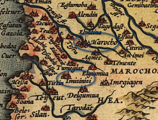
Maps of Abraham Ortelius
 Besides the inclusion of Amizmiz in various written historical
accounts, another indication of its importance can be found in the
many maps of Morocco that include it as well. The earliest and most
important of these is the 1570 atlas of Abraham Ortelius entitled
Theatrum Orbis Terrarum. This is generally regarded as the first
modern atlas, comprised of 53 maps covering the known world of the
time. His map of “Barbariae,” or the Barbary Coast, charts the modern
nations of Morocco, Algeria, and Tunisia. The major city of “Marocho”
(Marrakech) is included on the map, as is the smaller town of “Imizinizi.”
This spelling is no doubt a copying error of what was probably
intended to be “Imizmizi,” the name given by Leo Africanus. However,
the second “m” was miscopied as the letters “in.” By his 1595 edition
map of Morocco, this error had been corrected.
Besides the inclusion of Amizmiz in various written historical
accounts, another indication of its importance can be found in the
many maps of Morocco that include it as well. The earliest and most
important of these is the 1570 atlas of Abraham Ortelius entitled
Theatrum Orbis Terrarum. This is generally regarded as the first
modern atlas, comprised of 53 maps covering the known world of the
time. His map of “Barbariae,” or the Barbary Coast, charts the modern
nations of Morocco, Algeria, and Tunisia. The major city of “Marocho”
(Marrakech) is included on the map, as is the smaller town of “Imizinizi.”
This spelling is no doubt a copying error of what was probably
intended to be “Imizmizi,” the name given by Leo Africanus. However,
the second “m” was miscopied as the letters “in.” By his 1595 edition
map of Morocco, this error had been corrected.
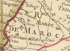
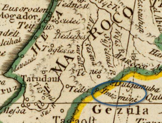
Below is a detailed section of the 1570 map of the Barbary Coast,
showing both “Imizinizi” and “Marocho”:
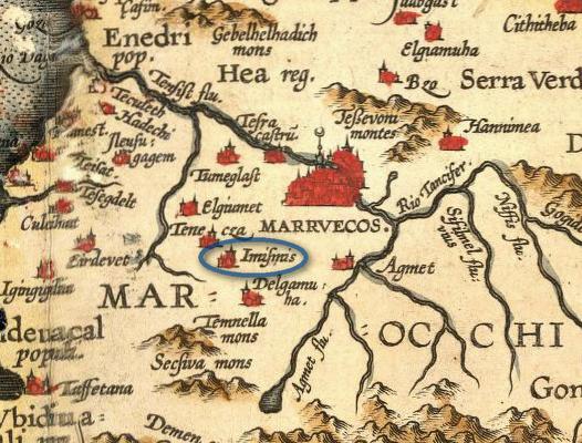
In 1595, Ortelius produced a map of Morocco that included
corrections from his 1570 map. Here, we see Amizmiz now written as “Imismis.” The
great city of “MARRVECOS” (Marrakech) is also visible:
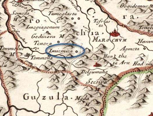
Map of Nicolas Sanson
One of the major reasons that Amizmiz held importance for European
explorers in the 16th to 19th centuries was due to the fact that it
was an important stop before crossing what are now known as the High
Atlas mountains. Leo Africanus mentions this fact in his description
of Amizmiz, but we also encounter evidence of it from a 1655 map by
Frenchman Nicolas Sanson. His map of Morocco clearly places “Imizmiza”
next to a route passing over the mountains into the region of “Guzula.”
The city of “Marochvm” (Marrakech) is also visible:
English Map of S. Bulton
The English map of S. Bulton from 1800 places “Imizmizi” barely
within the “Kingdom of Maroco,” an indicator that the town would have
been one of the last stops still under the control of the Sultan
before entering the mountains:
The British Explorations of the 19th Century
The 19th century saw an increase of British interest in Morocco and
its geography. The 1809 publication of An Account of the Empire of
Marocco by James Grey Jackson marked one of the earliest
firsthand accounts by someone who had spent a considerable amount of
time in the country. Jackson recognized the scarcity of reliable
information about Morocco, and suggested that “Leo Africanus is, with
very few exceptions, perhaps the only author who has depicted the
country in its true light” (11).
The first volume of The Journal of the Royal Geographical Society,
published 1831, contains an account of Lieutenant Washington's
expedition to Morocco in the winter of 1829-1830. He travelled south
of Marrakech into the Atlas mountains, but stayed northeast of Amizmiz
and therefore does not mention the town. However, it is interesting to
note what he does say about the Atlas mountain region and its people:
“How little is known of the central recesses of the Atlas! Doubtless
these valleys are all inhabited by a race of men probably as unmixed
as any existing, of whom nothing is known, hardly even a few words of
their language! Here is a field for an inquiring mind” (149).
Throughout the century, many explorers took up that challenge. In
fact, the exploration of the Atlas mountains was one of the major
recurring projects by members of the Royal Geographical Society during
its first seven decades of existence. In almost every instance,
Amizmiz was included in the itinerary of British explorers surveying
the people, plant life, and geography of the Atlas mountains.
1836 - John Davidson
In August of 1835, world traveller John Davidson embarked on a
journey that he had hoped would take him all the way to Timbuktu.
Unfortunately, he was killed approximately 25 days before reaching the
city. However, his account of travels in Morocco is filled with
stories of personal encounters with Arab and Berber Moroccans.
Published posthumously in 1839 by his brother under the title Notes Taken
during Travels in Africa, Davidson's journal includes entries
from February 21-23, 1836 that speak of the town of “Almishmish,”
which his brother interprets as “Imizmizi” in a footnote entry. The
entries are below:
Sunday, Feb. 21.—Therm. 47°
Our road was very beautiful, but trying, as we continued to ascend.
Some of the ravines surpass any thing I have ever seen. We passed
several tanks, built along the route, for the convenience of
travellers: the water was fine: I picked up many curious specimens. At
three P.M. we crossed the river Nefísah, a noble stream; above which
stands the town of El-Arján, where we saw the women's heads dressed
fantastically with flowers, and some fakirs adorned with curious
ornaments. We did not reach Almishmish [Amizmiz] till just before
dark. The Sheïkh Sídí Mohamed Ben Aḥmed is a great Káïd, who sent us
lots of presents. This, which I hoped would be an easy day, turned out
the hardest of any we had travelled. My horse is so knocked up, that I
find we must remain here the whole of to-morrow.
Monday, Feb. 22.—Therm. 50°
There was a little rain during the night. I have been so bitten by
fleas, that I look like a person with the small-pox. Our journey
yesterday was twenty miles, W. by S. and W. S.W.; we went a part of
the way up the dry bed of a river. I found here some varieties of
mixed stones, and a spring nearly equal to that at Vaucluse: there
were numerous mills scattered through the country, which was very
beautiful. We went to breakfast with the Káïd in his garden; it was
done in great style. Received lots of presents, and had many patients,
especially some old women; amongst the rest, there was brought to me a
man who had been attacked when employed in the fields, and had both of
his arms broken and half of his nose cut off: I replaced the piece of
the latter and set the arms, for which I had to manufacture
splints....Many of the ladies here are ill, but I have no remedy for
them. The chief of the Jews sent for me, to shew his hospitality; but
I have no appetite....I must, however, pay him and his household a
visit....Long—very long, will it be before I forget this
visit....Returned home about eleven, P.M.; it was very cold.
Tuesday, Feb. 23.—Therm. 50°
It turned very cold. I remarked on the road the strange manner of
keeping their corn in large baskets, plastered over, and set on the
roofs of the house, where they present a very odd appearance. Received
presents again before starting, which did not take place till nine,
A.M.
1839 - Royal Geographical Society
The ninth volume of the Journal of the Royal Geographical
Society mentions Davidson's earlier exploration of Morocco, and
specifically mentions the route he takes past Amizmiz. This no doubt
contributed to making Amizmiz a regular stop for later British
explorers. The relevant passage is reproduced here:
“In Marocco we find, from the rough note-book of the lamented
Davidson, that, following the steps of the British mission to that
country in 1830, related in the 1st Vol. of the Geographical Journal,
he proceeded from the city of Marocco across the plain in a S.S.E.
direction into Atlas, as far as the ruined town of Tasremút, at an
elevation of 3000 feet above the sea; thence turning to the westward
he continued along the valleys of Atlas by a route not laid down in
any of our maps, and which we are enabled partially to trace only in
that of M. de Gråberg; passing within a few miles of the site of
Aghmát Warikah, he appears to have issued from the mountains beyond a
place called Amishmish, perhaps Imizmizi of our maps, and then to have
crossed the plain to Mogador. Geographers cannot but feel grateful to
Mr. Thomas Davidson, the traveller's brother, for allowing his rough
notes of this novel route to be made public” (lxxii - lxxiii).
1871 - Joseph Hooker
 A close friend of Charles Darwin, Sir Joseph Dalton Hooker was one
of Britain's greatest botanists and explorers of the 19th century. For
two decades he was the director of the Royal Botanical Gardens, Kew,
during which time he made a visit to Morocco in 1871 in order to
collect specimens of plant and animal life. His account of
that journey, written with John Ball, was entitled Journal of a
Tour in Marocco and the Great Atlas (1878). That account contains
the most detailed description of “Amsmiz” up until that time period.
Hooker spends considerable length detailing the geography, plant life,
and notable people of Amizmiz and the Amizmiz valley. In fact, it is
through the Amizmiz valley that Hooker and Ball ascend the Atlas
mountains to the peak known at that time as Djebel Tezah, from which
the two view the Sous valley before returning back to Amizmiz. From
the vast amount of material, here are some notable passages:
A close friend of Charles Darwin, Sir Joseph Dalton Hooker was one
of Britain's greatest botanists and explorers of the 19th century. For
two decades he was the director of the Royal Botanical Gardens, Kew,
during which time he made a visit to Morocco in 1871 in order to
collect specimens of plant and animal life. His account of
that journey, written with John Ball, was entitled Journal of a
Tour in Marocco and the Great Atlas (1878). That account contains
the most detailed description of “Amsmiz” up until that time period.
Hooker spends considerable length detailing the geography, plant life,
and notable people of Amizmiz and the Amizmiz valley. In fact, it is
through the Amizmiz valley that Hooker and Ball ascend the Atlas
mountains to the peak known at that time as Djebel Tezah, from which
the two view the Sous valley before returning back to Amizmiz. From
the vast amount of material, here are some notable passages:
“This [Amizmiz] is the most considerable place on the northern
declivity of the Great Atlas, and, from the number of inhabitants, may
deserve to rank as a town. It stands on a shelf of flat rocky ground,
somewhat above the level of the adjoining plain, and nearly 200 feet
above the stream issuing from the mountains close at hand, which, for
want of any other name, we have called the Amsmiz torrent” (246).
“The Governor [of Amizmiz] was courteous and even friendly in manner,
and in general terms expressed his readiness to forward the objects of
our journey. He seemed pleased with the articles which Hooker
presented to him— a musical box, an opera-glass, and a long
sheath-knife; but when a thermometer was added, and an attempt made to
explain the use of the instrument, he at once returned it, saying that
it would be of no service, and that he would much prefer a brace of
pistols” (248).
“In the afternoon we went out for a stroll, and were able to form a
better idea than we had hitherto done of the character of the scenery.
The position of Amsmiz somewhat reminds one of that of villages in
Piedmont, that stand at the opening of some of the interior valleys of
the Alps, and still more of similar places in the Apennines of Central
and Southern Italy. The lofty hills that form the outer extremity of
the spurs diverging from the Great Atlas slope rather steeply towards
the plain, while the torrent issues from them through a cleft so
narrow that no path is carried along it into the valley. Trees, that
naturally clothe the outer ranges of the Alps, are here very scarce,
and the upper declivity, as commonly in the Apennine, is covered with
brushwood and low shrubs; while the lower slopes are partly under
tillage, or else planted with olive and fig trees. We descended from
the plateau, where our camp stood close to the town of Amsmiz at 3,382
feet (1,030.7 m.) above the sea, by steeply sloping banks to the level
of the torrent; and followed this for some distance, collecting plants
by the way; and then made a circuit among fields, enclosed by high
hedges, in which grew a profusion of climbing plants. The chief prize
of our excursion was a curious new species of Marrubium,
whose spherical heads of flowers are beset with long stiff bristles
hooked at the end, formed by the elongated lower teeth of the calyx”
(249).
1887 - Walter Harris
A fellow of the Royal Geographical Society, Walter B. Harris was a member of an official
1887 diplomatic mission to the Sultan of Morocco in Marrakech (depicted at right).
In his book The Land of an African Sultan, published 1889,
Harris details his time in Marrakech and and also some of the travels
that were taken by members of the diplomatic mission.
Four of those members, Harris included, were given special permission
by the sultan, Moulay Hassan, to visit the Atlas mountains in May of
1887. They were provided an interpreter, four soldiers, some servants,
and a letter from the sultan himself: “We give permission, by the help
of God, to the four Englishmen who are bearers of this letter to
travel in all parts of our Empire in which there is no present danger.
But in parts where there is danger, or where the inhabitants are in
rebellion, they must not go, whether in the plains or mountains. And
to those whose business it is, I give this command...that they take
care of them and pay all attention to their wants; that they accompany
them, and supply a fitting escort; and that they point out to them the
dangerous places, and advise them not to enter them. --Moulay Hassan”
In their journey, the Englishmen visit Ourika, Asni, and eventually
Amizmiz. Harris noted that “Amsmiz is a place of some size and
importance, and boasts a 'mellah,' or Jews' quarter, separated from
the walled town, of which latter the mosques and gateway are fine.
Altogether it is a most picturesque place, situated in the opening of
a large valley” (238).
Over the course of several days in Amizmiz, the
group explores that valley and some of the mountain villages near
Amizmiz: “Early next morning we started off up the valley, keeping to
the right-hand side. The path, the merest track in the side of the
precipice, was not a good one, as it was in no place more than two
feet to three feet wide, and proportionately slippery. Riding along
such roads as these is not over-pleasant work, especially when,
hundreds of feet below one, rushes a turbulent river, into which one
would ultimately alight...should the horse make one false step.
However, after some two hours and a half of more or less holding one's
breath, we emerged into a valley running at right angles to the one we
were in. The scenery all along the road was very grand; far below
boiled and bubbled the river, its banks green, vividly green, with
narrow strips of corn-fields and groves of walnut-trees, while a line
of crimson oleanders marked out the river's edge. The valley we
entered was very lovely. At the end, which opens into the great
valley, stands a village of some size, by name Imminteli, close under
the walls of which runs a swift, clear, deep river, whose bed is cut
out in the solid rock. On each side of the river is a lawn of green
grass, the whole shaded by gigantic walnut-trees. We crossed the river
some few hundred yards up to where it issues from the solid rock, a
most curious spot, for there is no cave, simply a pool of water at the
foot of the precipice—a clear, deep pool, from the centre of which,
far down in its transparent depths, issues the stream” (240-241). The
Amizmiz
valley, the village of Imintala [Imminteli], the famous spring that flows
into a river surrounded by grass and walnut trees—all of these can still be visited today (see our villages
map and our custom excursion itinerary).

1888 - Joseph Thomson
 A Scottish geologist and explorer, Joseph Thomson was famous for his
travels throughout Africa. A fellow of the Royal Geographical Society,
Thomson made a trip to the Atlas mountains in 1888. A year later he
published a personal narrative of that trip entitled Travels in
the Atlas and Southern Morocco: A Narrative of Exploration. In
it, he describes the geography and
people of Amizmiz and the river valley to the south. He is
also the first person (that we know of) to ever photograph Amizmiz.
A Scottish geologist and explorer, Joseph Thomson was famous for his
travels throughout Africa. A fellow of the Royal Geographical Society,
Thomson made a trip to the Atlas mountains in 1888. A year later he
published a personal narrative of that trip entitled Travels in
the Atlas and Southern Morocco: A Narrative of Exploration. In
it, he describes the geography and
people of Amizmiz and the river valley to the south. He is
also the first person (that we know of) to ever photograph Amizmiz.
Thomson begins his description of Amizmiz with a general survey of the
geography: “Amsmiz lies at the foot of the outer mountain terrace of
the Atlas, and close to the entrance of a narrow glen, through which
may be caught a glimpse of the backbone of the range, only some eight
miles distant. The town stands at an elevation of 3020 feet above the
level of the sea, according to our boilingpoint thermometer” (282).
He speaks of the people as well, including the sizeable number of
Jewish residents.
“The population of the town of Amsmiz we guessed to be somewhere about
2000, of which a very considerable proportion are Jews” (283). He
comments that the Jews of Amizmiz
“had a manly and independent air about them sufficiently rare in these
lands, and seemed to be on very good terms with themselves and with
the government” (283). Regarding all the inhabitants of the town,
Thomson remarks that they are a population of
“fine healthy men and women” (284).
Much more time is spent by Thomson describing the river valley and
mountains to the south. In fact, chapter 20 of his book is titled “Glen of the Wad Amsmiz,”
the word “wad” being Arabic for river. The entire chapter recounts
Thomson's exploration of the Amizmiz river valley, the same valley
that our excursions visit nowadays (see our maps).
Thomson remarks on the incredible beauty of the area:
“It had never before been our good luck to find such a charming
camping-ground. In the Atlas flat pieces of ground covered with green
sward and sheltering trees are extreme rarities; but here, in the glen
of the Wad Amsmiz, we had a delightful bit of turf on which to pitch
our tents, splendid walnut trees to shade them, a noisy torrent to
babble at our feet, and majestic mountains to fold us in their giant
arms and cool the tropic heats. Berber villages also were at hand, to
send us store of corn for mules and horses, milk, eggs, and fowls for
ourselves, and couscous, tajine, and barley bannocks for our attendants”
(290-291).

1897 - R. B. Cunninghame Graham
 Bontine Cunninghame Graham was a Scottish adventurer and writer who
also spent several years involved in politics. In 1897, he travelled
to Morocco with the hopes of reaching the southern city of Taroudant
in the Sous valley, an area that had not been reached by earlier
explorers. Graham disguised himself as a Turkish doctor in order to
avoid the obstacles that often troubled Europeans who openly travelled
in Morocco. Despite his efforts, he failed to reach Taroudant when he
was imprisoned for four months by Berbers in the Atlas mountains. His
1898 book about his time in Morocco, entitled Mogreb-el-Acksa: a
journey in Morocco, contains numerous references to Amizmiz.
Bontine Cunninghame Graham was a Scottish adventurer and writer who
also spent several years involved in politics. In 1897, he travelled
to Morocco with the hopes of reaching the southern city of Taroudant
in the Sous valley, an area that had not been reached by earlier
explorers. Graham disguised himself as a Turkish doctor in order to
avoid the obstacles that often troubled Europeans who openly travelled
in Morocco. Despite his efforts, he failed to reach Taroudant when he
was imprisoned for four months by Berbers in the Atlas mountains. His
1898 book about his time in Morocco, entitled Mogreb-el-Acksa: a
journey in Morocco, contains numerous references to Amizmiz.
Originally, Graham had no intention of passing through Amizmiz. After
having arrived in Mogador (modern day Essaouira), three routes were
available for reaching Taroudant. Graham's first choice was to travel
along the coast to Agadir and then eastward. This was the preferred
course simply because he would not need to traverse the Atlas
mountains. Unfortunately, the local Howara tribe that controlled the
road from Agadir to Taroudant was in rebellion, and the road was
reportedly closed. Graham had two other routes available, both of
which required his passing over the Atlas mountains. Of the two, he
first chose the road leading from the town of Imintanout south across
the mountain range. He encountered another set of unfortunate events
upon his arrival in Imintanout, however. The tribe of Beni Sira closed
the pass because they were unhappy with the newly appointed governor,
and in recent days they had been opening fire on anyone trying to
cross the Atlas through their territory. Graham had only one other
route available to him if he wanted to get over the Atlas and reach
Taroudant: take the upper and more difficult pass to the Sous valley.
This route began in Amizmiz.
When Graham first arrives in Amizmiz, he describes a bit of what he sees.
“We crossed the Wad el Kehra, and early in the afternoon tied up our
animals under a fig-tree, with a river running hard by, a stubble field in
front, and Amsmiz itself crowning a hill upon our right. Amongst the ‘algarrobas,’ fig-trees and poplars, swallows flit, having come south, or
perhaps migrated north from some more southern land. At the entrance of the town stood the palace of the Kaid, an enormous structure made of mud and
painted light rose-pink, but all in ruins, the crenellated walls a heap of
rubbish, the machicolated towers blown up with gunpowder. The Kaid, it
seems, oppressed the people of the town and district beyond the powers of
even Arabs and Berbers to endure; so they rebelled, and to the number of
twelve thousand besieged the place, took it by storm, and tore it all to
pieces to search for money in the walls” (109).
“An orange grove, backed by a cane-brake, with the canes fluttering like flags, was near to us; cows, goats, and camels roamed about the outskirts of the town, as in Arcadia—that is, of course, the Arcadia of our dreams—or of Theocritus.”
“Jews went and came, saluting every one, and being answered: "May Allah let you finish out your miserable life"; but yet as pleased as if they had been blessed. Their daughters came, like Rebecca, to the well—all carrying jars—unveiled, and yet secure, for in this land few Moors cast eyes upon the daughter of a Jew.”
“Upon the ramparts, shadowy white-robed figures, with long guns, go to and fro, guarding the town from hypothetic enemies....On every hedge are blackberries and travellers' joy; whilst a large honeysuckle, in full flower, smells better than all Bucklersbury in simple time; a jay's harsh cry sounds like the howl of a coyote, and Europe seems a million miles away. In the evening light, the footpaths, which cut every hill, shine out as they had all been painted by some clever artist, who had diluted violet with gold” (111).
The Early Twentieth Century
The turn of the century brought with it a diminished interest in Amizmiz among British explorers and scientists. Much of the geography and flora of the Amizmiz valley had by now been documented and there was less need for using Amizmiz as a base for further exploration of the Atlas mountains. Nevertheless Amizmiz continued to be a popular cultural destination for those foreigners travelling in Morocco—especially because of its close proximity to Marrakech. Photographers, too, recognized Amizmiz as an easily accessible location for documenting, in print, the life of Berbers in the Atlas mountains. In the early twentieth century, Amizmiz would continue being mentioned regularly among written travel accounts of the country.
The Pall Mall Magazine - 1900
Writer F. G. Aflalo contributed a piece on “Morocco, the Imperial
City” to the British literary magazine
The Pall Mall in its January 1900 issue. Including photographs taken by the author himself, Aflalo
describes Marrakech (also known at the time as Morocco City) from a
purely literary, outsider's perspective. His account includes a
mention of “Amsmiz,” which he visited en route to the Atlas mountains
where he intended to search for a famous type of wild sheep in the
area:
“Away to the south-west [of Marrakech], just as the great [Atlas] range lifts itself above the burning plain, lies Amsmiz, the city of almonds, nestling amid its groves of perfume and colour, and showing on its battered barbicans traces of political differences with the dynasty, or with some robber tribe from the hills. History is not my theme, and I care not which. But the remains of the struggle are picturesque” (58).

Eugène Aubin - 1902
A Frenchman and world traveller, Eugène Aubin visited Morocco in
late 1902, a fortunate time when relations between the Sultan and
Europe “had, for the first time, opened up in some degree this
country, so hostile to foreign influences” (vii). An English account
of his travels was published in 1906 under the title Morocco of
To-day. Among his many descriptions of the country, Aubin speaks of Amizmiz:
“Amsmiz is a little town that nestles at the very foot of the range,
on the banks of a tributary of the river Nefis, whose ravine has a
setting of snowy summits. The earth dwellings, crowned by a square
minaret, huddle together on a piece of rising ground, dominated by the
ancient Kasbah of the Kaïd of the tribe. To-day the Kasbah is only a
heap of ruins. It was destroyed at the time of the death of the Sultan
Moulay el-Hassan, when the tribes of Southern Morocco, taking
advantage, as their custom is, of this unique opportunity of shaking
off the yoke of authority, rose in revolt against their Kaïds, and
pillaged the Jews. The revolt spread till it was almost universal, and
it was only the most powerful of the chiefs that were spared. The Kaïd
el-Masmazi has thought it wiser not to rebuild the ruined Kasbah. He
has removed his residence to a spot outside the city, in an azib
with fortified walls. Like all the other Kaïds, he is elsewhere, and
in his absence his son, Si Mohammed ould el-Hassan, rules the tribe in
the capacity of Khalifa” (43).
Copyright © 2020 Berber Travel Adventures